|
On 4/25/23 the team presented for the Celebration of Student Achievement at TCNJ. For this presentation, a poster was created. The poster features the abstract to our project and shows the final designs for each sections. These final designs are the same as shown in the last update, but readability improvements were made for the poster. Below is a screenshot of our COSA poster. 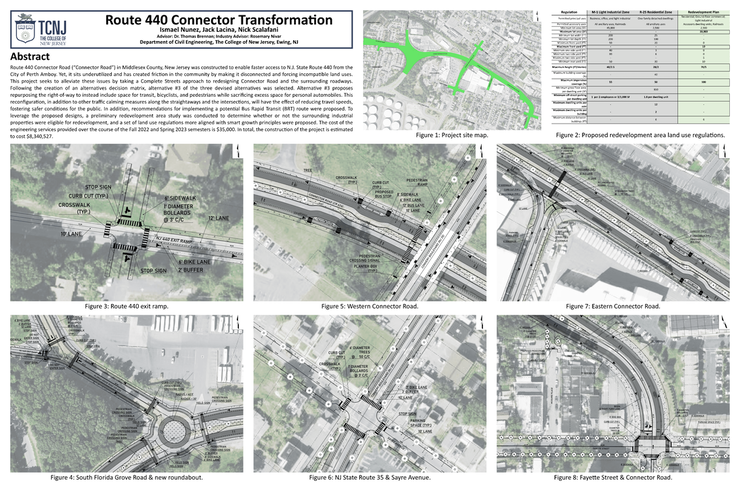 The poster used for the COSA presentation
0 Comments
Throughout the month of March, the team has been hard at work finalizing our designs. This process involved long hours working together in Civil 3D to make realistic engineering drawings that all used the same standards and similar ideas. Below will share some insights into the design process for each section of our project site and the major changes we have made in order to create our final designs. Sections 1 and 2 These sections were created by Nick Scalafani. They remained relatively similar to the design laid out during the alternative design process. 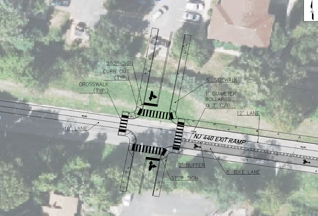 Section 1: NJ 440 Exit Ramp added intersection This design keeps the intersection along NJ 440's exit ramp. This intersection aims to connect the North and South communities and provide sidewalks for these communities into the heart of Perth Amboy. One major change is the addition of the bike lane along the eastern side of the exit ramp, providing more transportation options for the local residents. Another major change between our initial plans for this area and our final design is that the traffic signal was removed. Instead, we decided to shift our design to having stop signs along the newly created minor streets. The purpose for this was to avoid cars backing up the NJ 440 exit ramp, which would create a major safety issue. 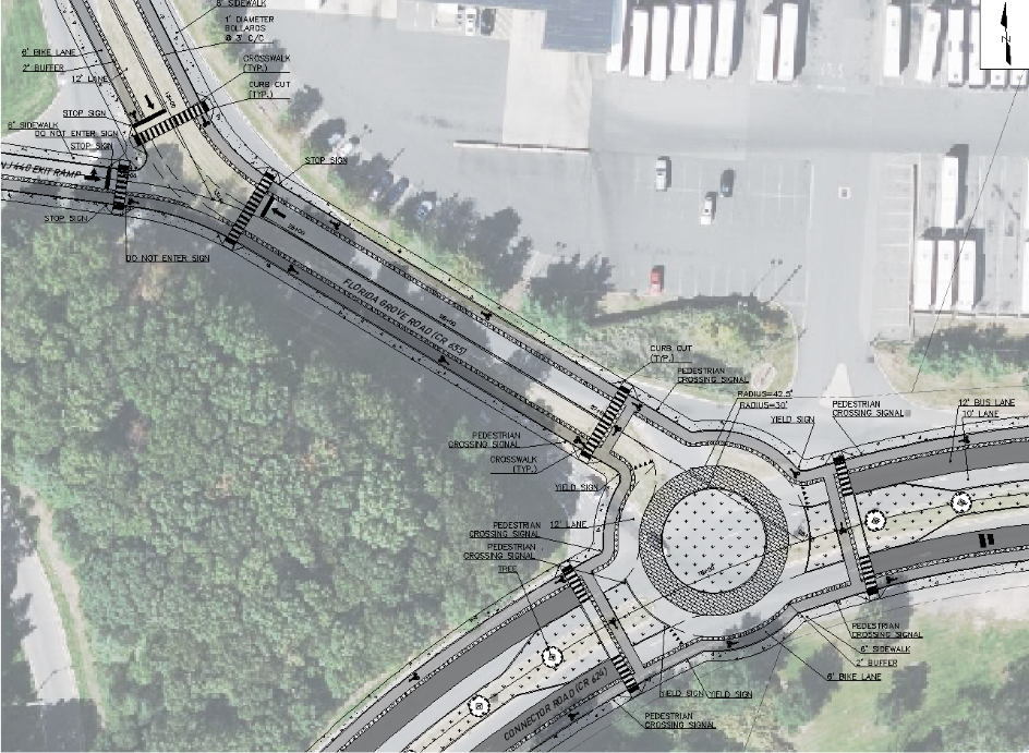 Section 2: South Florida Grove Road and Connector Road roundabout This section remained very similar to our initial designs laid out in the alternatives. The intersection with the NJ 440 exit ramp and South Florida Grove Road has been made more accessible and walkable with added crosswalks and new cross-sections. South Florida Grove Road then intersects with Connector Road with a newly created roundabout. The cross-section for Connector Road has remained the same as previously shown, but there are two major differences in the final roundabout design. First, the roundabout is a single lane, with a truck apron around the middle for any industrial traffic. Second, the approach to the roundabout has been modified to reflect the new single lane roundabout. The transit lane merges into the bus lane to create a smooth transition into the roundabout. Sections 3 and 4 These sections were created by Jack Lacina. Section 3 had some major changes, but section 4 remained similar to the design laid out during the alternative design process. 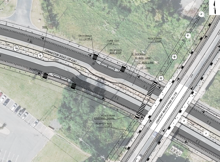 Section 3: Western Connector Road redesign This redesign is vastly different from the alternative design initially proposed. It keeps the major facet of that design, which is the north and south connection through a new striped cross-walk on Connector Road. Additionally, the cross-section remains the same as outlined in the alternative design. However, there are many major changes. The crosswalk has been shifted to be closer to the bridge. This relocation allows for easy access to the new pedestrian ramps that are located to the north and south, bringing even further connectivity to the area. Additionally, bus stops have been proposed in this area because of its proximity to the local shopping center and to make the transit lane more useful. 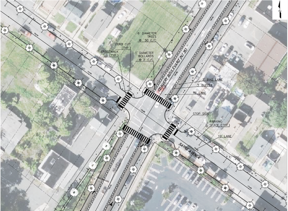 Section 4: Redesign of NJ State Route 35 and Sayre Avenue (and Fayette Street) This section remains very similar to the design laid out in the alternative design section. Both intersections keep very similar designs, so only one is shown in the image above. It keeps the striped crosswalks between all of the approaches and the new cross-section for NJ State Route 35. There are still bump outs added, but now they are only on the minor street. One major difference is the abundance of trees along all sidewalks to provide shade towards pedestrians and parked cars. Section 5 and 6 These sections were created by Ismael Nunez. Both sections remained relatively similar to the designs created in the alternative design process. 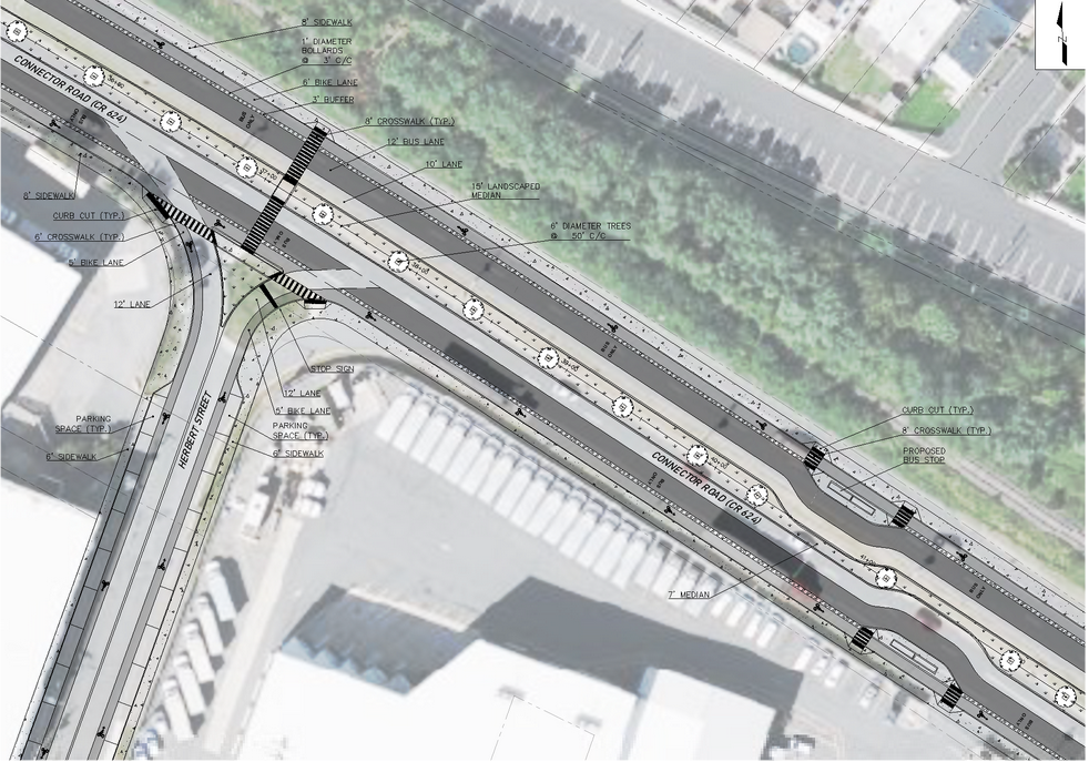 Section 5: Eastern Connector Road redesign This redesign remains largely the same with some small additions. Crosswalks have been added to Herbert Street to increase pedestrian connectivity. Additionally another crosswalk has been added connecting the north and south sides of Connector Road. Bike lanes have been added along Herbert Street as well to improve transportation options. One major difference is an additional bus stop along Connector Road with the same design as previously shown. 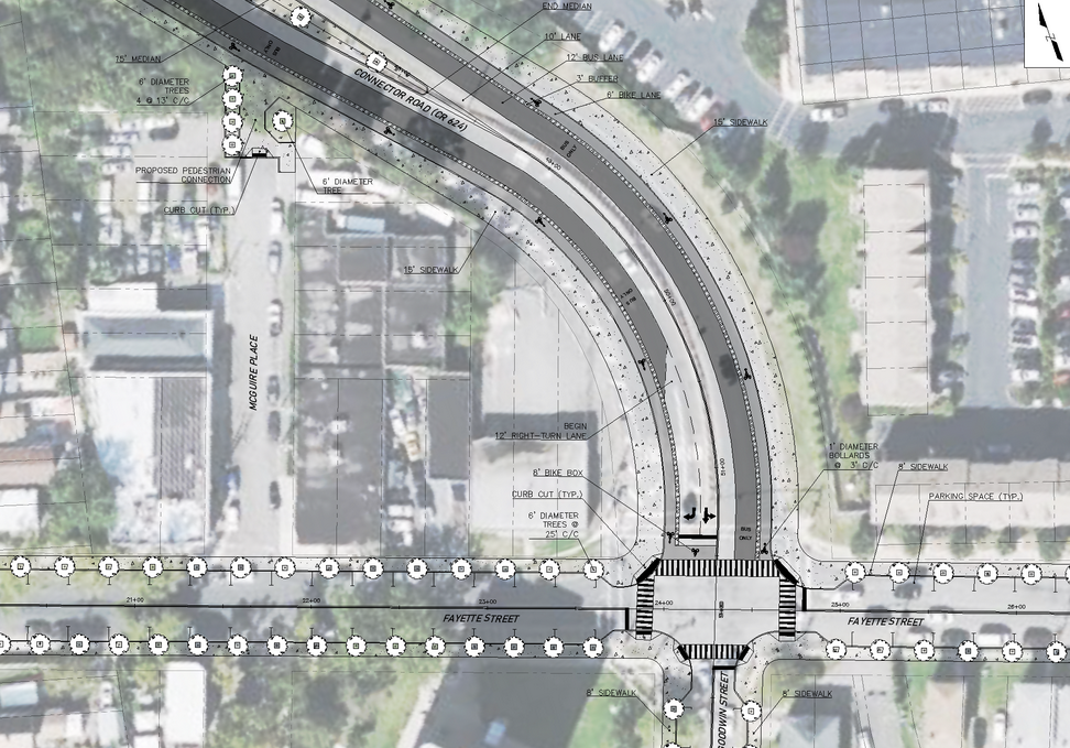 Section 6: Fayette Street and Connector Road Intersection This design has remained mostly the same to the alternative design. North of the intersection with Maguire place, a pedestrian walkway has been added into the public right of way. The intersection has striped crosswalks with bump outs on all approaches except for Connector Road. One major difference in the final design is the reduction of lanes in Connector Road leading to only 2 turning lanes. This is to reduce the complexity of this intersection.
Before officially starting the updated designs, the group decided to update and finalize the existing site plan in accordance with the recommended changes from Dr. Brennan. Site Plan Additions The first adjustments made were in regards to the site plan itself by making changes in model space. The first change added was rebuilding the alignments with the existing roads to be more accurate with the existing site. The rebuilt alignments also provided for more accurate elevation data for the profiles. New profiles were created for these alignments, including profiles that were previously missing. In plan view the name of the roadways were added to better navigate the site plan. Another new addition to the site plan was the inclusion of parcels into the site plan. This gives an idea of the surrounding land and the parcels that would be affected by our changes in the area. Finally, elevation contours were also added to the site plan to show changes in elevation along the site, which is especially useful near the Route 35 bridge. These updates complete the site plan and give a better overview of the existing site of our project and its surroundings. Below is a comparison between the old and new site plans that shows off these new adjustments.  An old overview of the site plan. It looks incomplete and does not give a great sense of the existing site that is outside of the project's scope. 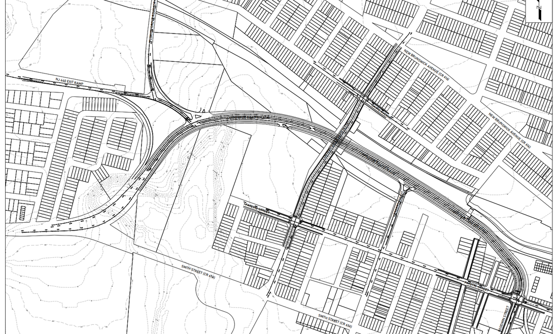 An updated overview of the site plan. It looks more complete and gives a better overview of the site and its surroundings. Clarity AdjustmentsWhile additions were made to the existing site plan, the team also wanted to make updates for clarity, making the plans more readable and organized. The first of these changes was to create a new title block for the project. This updated title block uses larger text and makes use of the white space from the old title block. Additionally, layers were reworked to create a greater difference in line weights and make the important objects stand out more. Overall, our team wanted to make more use of the white-space that was available. The images below show a comparison between our old and new title blocks for a profile view. 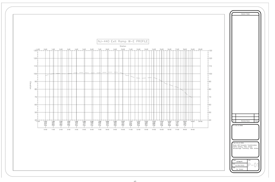 The old layout profile view for the NJ-440 Exit Ramp W-E with the old title block. 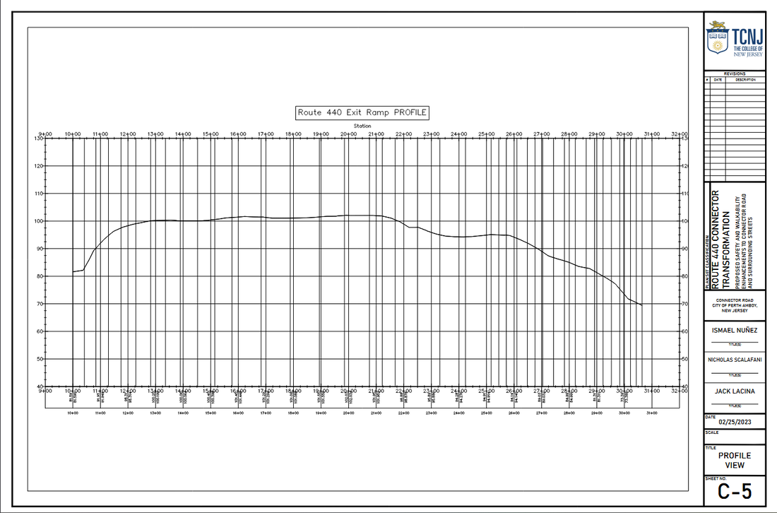 The new profile view for the NJ-440 Exit Ramp W-E with the new title block. Drafting the Final Designs The final design work has begun and this section will discuss some of the initial steps taken as the team works through its drafting. Standards and Guidelines As discussed in our reports, there are a set of standards and guidelines that will be used to help aid our final design. While creating our alternatives, these standards and guidelines were considered, but for the most part were unused as the focus was on generating different viable options. Now that the alternative was selected, these standards and guidelines are seeing much more use and have been integral to the design process. Below are some examples relevant design standards and guidelines that our project is using. Site Plan Updates With an updated site plan, there is now a solid foundation for the design work for the project site. Some of the first changes made include adding in new alignments for the updated site, specifically the roundabout that is added at the intersection of Florida Grove Road and Connector Road. Associated with this new alignment are new profiles that the team is taking a look at to ensure that the roadway grades will remain within standards and still provide a minimal impact to the cost of the project.
Traffic models are a necessity when analyzing transportation engineering project. These tools help us figure out how good an intersection is as it exists and with its proposed changes. Currently we have our existing Traffic Model to view for data, which models the intersections of the NJ Route 440 Exit Ramp and Florida Grove Road, South Florida Grove Road and Connector Road, and Fayette Street and Connector Road. Below are images of these models and their simulations in action. 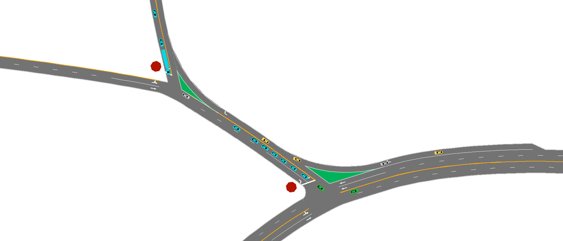 This is an in-progress photo of the simulation for the intersection of South Florida Grove Road and Connector Road. 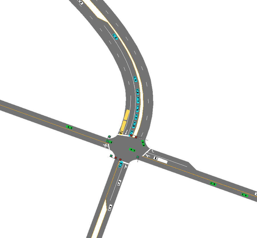 This is an in-progress photo of the simulation for the intersection of Fayette Street and Connector Road. How These Were Created And What The Data Says To create this traffic model, important data was needed regarding the traffic volume of these intersections and the geometry of the roadway. We can estimate the geometry of the roadway by using Google Earth, and from our past site visits to the area and by using NJDEP data, we can get the predicted traffic volume for these intersections. These models should be analyzed under peak flow, so the highest volume counts were used. Below are images of our volume graphs and the volumes used for our models. The important part of this is the Level of Service associated with these intersections, which shows how much delay a driver might face. This statistic is inherently focused on the service towards drivers and not pedestrians. For the Florida Grove Road and exit ramp intersection, there is a level of service of A. For the Florida Grove Road and Connector Road intersection, there is a level of service of F. For the Fayette Street and Connector Road Intersection, there is a level of service of C. Below are images showing this data in Synchro. We know from the lack of pedestrian infrastructure in this area that this area already fails in servicing pedestrians. Additionally, from looking at the model and data behind it, we can see that this area does not do particularly well in servicing cars either. Through our redesign, we aim to provide improvements for both drivers and pedestrians through redesign. Our team came up with three alternative designs, as discussed in previous updates. Out of the previous designs, we have chosen to go with alternative 3. Below is a recap of what alternative 3 looks like. 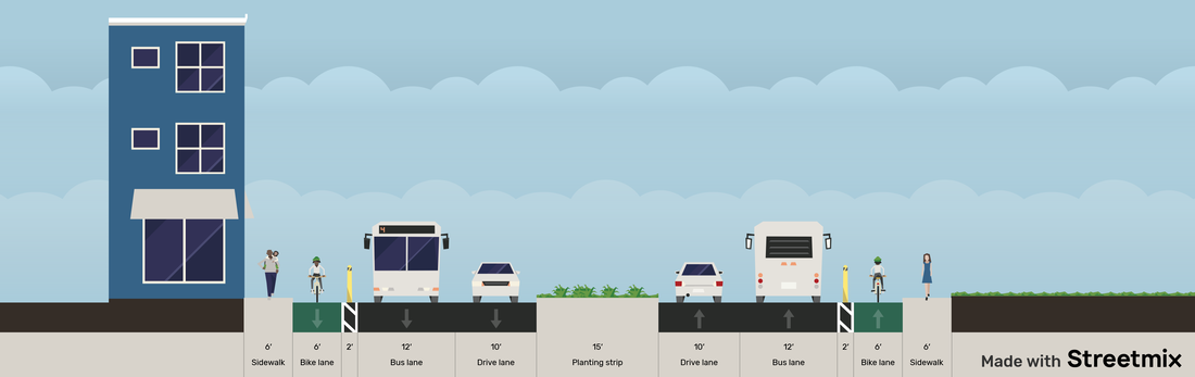 An overview of the cross-section used for Connector Road for alternative 3. 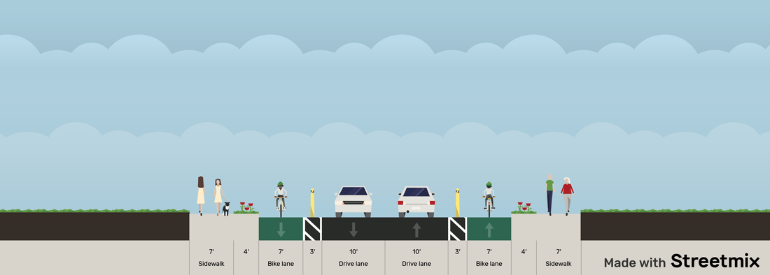 An overview of the cross-section used for Route 35 for alternative 3. Choosing the design Our reasoning behind choosing alternative 3 was based on using a design matrix. The design matrix ranked our choices based on accessibility, connectivity, constructability, economic score, environmental score, health and safety, and political score. These criteria were all weighted based on how important we thought they were to the project. Overall alternative three is the best because of its focus on compromising and being economical. 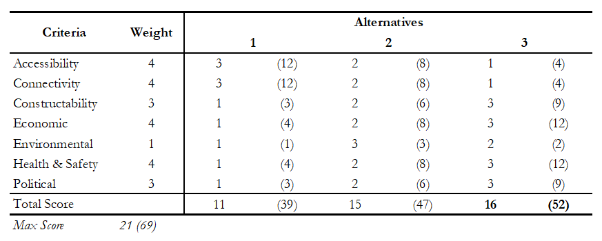 Our design matrix used to select our design. A closer look at the design Our team drafted up what this design might look like using Auto CAD Civil 3D. Each team member was responsible for drafting their locations. Below are close-ups of the important design areas. The idea behind the exit ramp design was to bring connectivity between the Keasbey and Florida Grove communities that were separated by the previous exit ramp. This is done through a signalized intersection that will provide safe crossing and timing that will still keep up with the flow of traffic. The roundabout provides a much safer and more intuitive design to the intersection of South Florida Grove Road with Connector Road. The western stretch of Connector Road has become more walkabout with the new intersection and addition of a crosswalk to further promote connectivity between the north and south sides of Connector Road. Route 35's intersections with Sayre Ave and Fayette Street have been redesigned to be more pedestrian friendly, as well as the strip of Route 35 itself mostly through re-striping. The eastern stretch of Connector Road has created a better connection with Humbert Street to be more pedestrian and cyclist friendly, with a one-way bicycle lane and a one-way car lane. Finally, the intersection of Connector Road and Fayette Street has been redesigned to be more pedestrian friendly, mostly through re-striping and bump outs. The proposed designs above are extremely cost-friendly which has helped in the decision to choose alternative 3 when compared to the other alternatives. Our quarterly report was completed and a large portion of this was our site plan. It features the existing conditions for our site in both plan and profile view and the current traffic models. With future recommended edits that we received from our technical advisor, we expect that the site plan will be longer for our next report. 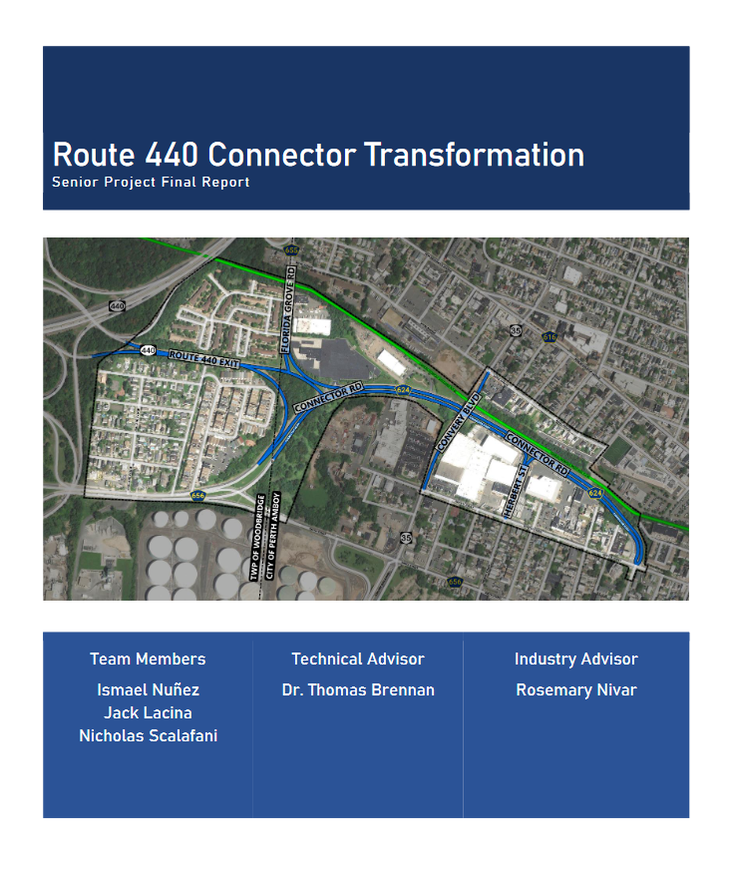 Title page for our report showing our site's map Plan and Profile As a part of completing the quarterly report, the site plan needed to be completed to show the current conditions of our project area. The team used Civil 3D to draft the site plan for both the plan view and profile view. Civil 3D allowed for the easy creation of the profiles, which we created by using the alignment feature and importing a raster of elevation data into Civil 3D. In conjunction, these will give us an accurate overview of what our site looks like. This will be important for when we create our final design dimensions in the future as we try to work with the surrounding area as much as possible and limit cut and fill operations. Below is a overview of our drafted site plan and one of our drafted profiles. 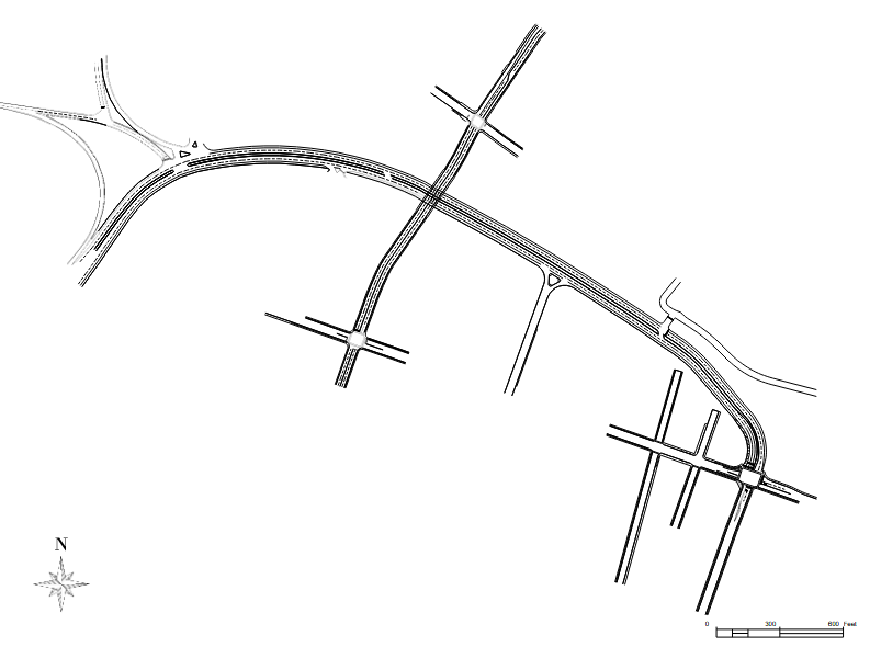 Existing Site Plan Overview 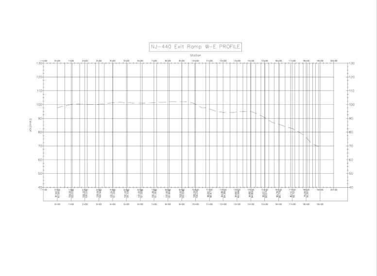 Existing profile for the NJ-440 Exit Ramp Our group came up with and presented three alternatives, one that focuses on the NJ-35 realignment, one that focuses on long-term redevelopment, and one final one that is a mix between the other two, focusing on being cost-effective. 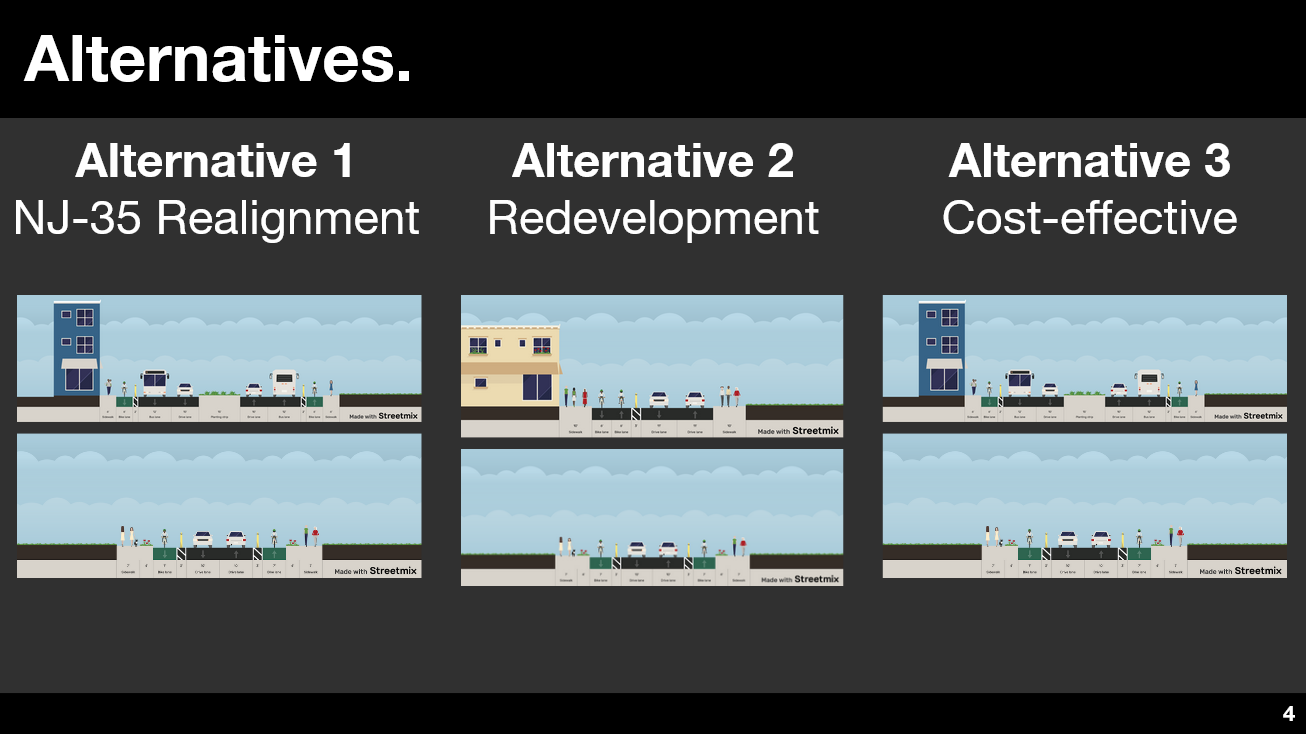 A slide showing all of our alternatives and the cross-sections associated with them. The image on the top are for Connector Road and the images on the bottom are for NJ State Route 35. A closer look at the alternatives Each alternative uses the same new cross-section for NJ State Route 35 to promote north and south connectivity. NJ State Route 35 Cross-section Alternative 1 focuses on vertically realigning NJ State Route 35 to create an intersection with Connector Road. The reason behind this alternative was that it would promote connection between the north and south for pedestrians and cyclists and reduce speeds along Connector Road to increase safety and walkability. Other changes with this alternative further promote safety and walkability along Connector Road. Below are images of this main intersection and the cross-section used for Connector Road. Alternative 2 focuses on major changes to the Connector Road cross-section. The reason behind this alternative was in favor of long-term growth along Connector Road. By narrowing the road greatly, there would be more incentive for residential and commercial growth in the area through mixed-use zoning which helps create a "sense of place" along Connector Road. It would also massively increase safety and walkability along Connector Road by narrowing the road. Below are images of the plan view of Connector Road and the cross-section used for Connector Road. Alternative 3 focuses on striking a balance between alternatives 1 and 2. By using the cross-section of Connector Road of cross-section 1 and redesigning the intersections of NJ State Route 35 instead of vertical realignment, it provides the most cost-effective solution to the problem. Most redesigns revolve around re-striping and making use of existing infrastructure. Below are images of the plan view for the new NJ State Route 35 intersection and the cross-section used for Connector Road. We made our first site visit as a team. Our plans for this site visit included just a simple walk-through of the site and to conduct a traffic count at each intersection. Our team took a walk-through of the site and took pictures that are shown below. We witnessed school traffic during our second traffic count as well, providing some invaluable data for us when creating our traffic models. Some screenshots of the data we collected is shown in a slideshow below. These pictures are important for us to get a street visualization of the important parts of our site and to understand our area when creating our designs. Our team leader visited the site for a neighborhood walk-through and to take some initial pictures of the site. The pictures are a pedestrian's perspective of some of project areas, as well as notable locations in the surroundings. These pictures will be important as we consider the changes our project will have on the surrounding area. We plan to return in the coming weeks to conduct traffic counts and take more pictures of our site.
The location of our project is on Route 440 Connector Road, located mostly in Perth Amboy, New Jersey. The project area is shown in blue in the map below. Route 440 is nearby and the exit leads onto Connector Road. This road serves as a way to get in and out of the city, especially for industrial vehicles. However, in recent years, small-scale residential and commercial demand has far outpaced the need for this industrial road and Connector Road now acts as a large barrier in the otherwise connected community. 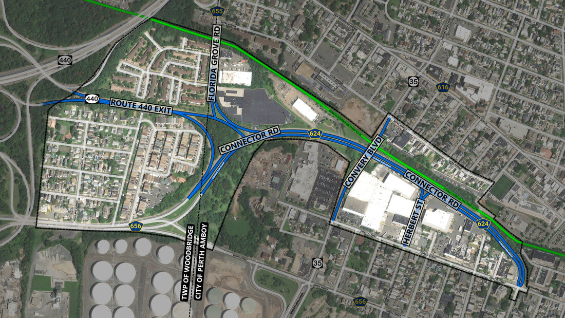 A aerial view of the project location showing the project area in blue. An example of the connectivity concerns in this area is the community of Keasbey, located in the lower-left hand corner of the project site. Access to Keasbey is cut off due to being surrounded by Route 440 and Connector Road, essentially making it an island. This community is entirely residential, and if a resident wanted to do something as basic as going to a grocery store, they would need a car or risk their lives crossing and walking along these dangerous roads. Our project aims to alleviate these concerns and promote walkability, connectivity, and safety by using a Complete Streets approach during the design process.
|
AuthorsThis blog is managed by all team members. You can meet the team using the navigation menu above. Archives
April 2023
Categories |


 RSS Feed
